Anyone who wants to share conditions info is welcome to do so here. You cam also check www.backpackingintherubymountains.info There is lots of good stuff there and he keeps that site pretty updated. See you in a few weeks!
Sunday, June 24, 2012
Missing in action
I'll be brief since I'm on my iPhone... I'm going to be away from my computer for a few weeks and won't be able to answer emails for a while.

Monday, June 18, 2012
Here, fishy fishy...
I'll be the first to admit it... I am not a passionate fisher person. I am a utilitarian fisher person- if I'm hungry I'll attempt catching a fish in order to resolve the situation. Otherwise, I tend to leave them to their fishy lives.
That said, if one plans on catching a fish for dinner in the high alpine lakes of the Rubies and East Humboldts, it's best to know which lakes actually have fish in them.
Here's info from a series of charts that NDOW has up on their website, as well as some information passed along by a reader.
Angel Lake - brook, rainbow, tiger, speckled dace
Birdeye Lake - none
Boulder Lake - ?
Castle Lake - none
Cold Lakes - brook
Dollar Lakes - none
Echo Lake - brook
Favre Lake - brook
Greys Lake - cutthroat
Griswold Lake - cutthroat
Hidden Lakes - cutthroat
Island Lake - brook
Lamoille Lake - brook
Liberty Lake - brook, mackinaw
North Furlong Lake - none
Overland Lake - brook
Robinson Lake - brook
Seitz Lake - ?
Smith Lake - cutthroat
Soldier Lakes - none
Steele Lake - brook
Verdi Lake - cutthroat, rainbow
Winchell Lake - ?
There's some mixed information about Boulder, Seitz and Winchell. According to the NDOW website, Boulder has good fishing for brook trout. However, a reader passed along the information that the fish have been gone from that lake for a few years now, and that NDOW's website is out of date. The bottom line - if you're heading to Boulder Lake make alternate dinner plans.
Seitz isn't one of the lakes up there listed by NDOW as having a fish population. However, Joe Doucette from NDOW listed Seitz as one of the local alpine lakes stocked with cutthroat in a recent fishing conditions column he has in the Elko Daily Free Press. I'd tend to trust Joe on this one - he's the local.
Winchell isn't listed as having fish on NDOW's charts, either, and I've had that confirmed by one of this blog's readers. It's a pretty small lake (although I've pulled really nice fish out of smaller). However, the USFS trailhead sign at the Winchell trailhead shows fishing as one of the recreational options there. You be the judge, although it's quite true that "fishing" is not the same thing as "catching."
One final note - according to Joe there was a significant winter kill event at Hidden in 2010-2011. The lake has been restocked with fingerlings, and the fishing isn't likely to be good there until they grow up in a couple of years. Several friends of mine have had excellent fishing experiences at Hidden, so hopefully this round of trout will have better luck than the previous ones.
That said, if one plans on catching a fish for dinner in the high alpine lakes of the Rubies and East Humboldts, it's best to know which lakes actually have fish in them.
Here's info from a series of charts that NDOW has up on their website, as well as some information passed along by a reader.
Angel Lake - brook, rainbow, tiger, speckled dace
Birdeye Lake - none
Boulder Lake - ?
Castle Lake - none
Cold Lakes - brook
Dollar Lakes - none
Echo Lake - brook
Favre Lake - brook
Greys Lake - cutthroat
Griswold Lake - cutthroat
Hidden Lakes - cutthroat
Island Lake - brook
Lamoille Lake - brook
Liberty Lake - brook, mackinaw
North Furlong Lake - none
Overland Lake - brook
Robinson Lake - brook
Seitz Lake - ?
Smith Lake - cutthroat
Soldier Lakes - none
Steele Lake - brook
Verdi Lake - cutthroat, rainbow
Winchell Lake - ?
There's some mixed information about Boulder, Seitz and Winchell. According to the NDOW website, Boulder has good fishing for brook trout. However, a reader passed along the information that the fish have been gone from that lake for a few years now, and that NDOW's website is out of date. The bottom line - if you're heading to Boulder Lake make alternate dinner plans.
Seitz isn't one of the lakes up there listed by NDOW as having a fish population. However, Joe Doucette from NDOW listed Seitz as one of the local alpine lakes stocked with cutthroat in a recent fishing conditions column he has in the Elko Daily Free Press. I'd tend to trust Joe on this one - he's the local.
Winchell isn't listed as having fish on NDOW's charts, either, and I've had that confirmed by one of this blog's readers. It's a pretty small lake (although I've pulled really nice fish out of smaller). However, the USFS trailhead sign at the Winchell trailhead shows fishing as one of the recreational options there. You be the judge, although it's quite true that "fishing" is not the same thing as "catching."
One final note - according to Joe there was a significant winter kill event at Hidden in 2010-2011. The lake has been restocked with fingerlings, and the fishing isn't likely to be good there until they grow up in a couple of years. Several friends of mine have had excellent fishing experiences at Hidden, so hopefully this round of trout will have better luck than the previous ones.
Wednesday, June 13, 2012
What a bummer. :(
Well, folks, I hate to say it but I've had to change the comments part of this site so that only registered users can comment. Since just about everybody and their dog has a Google account this shouldn't be limiting, but I have to admit I've enjoyed some of the rhubarbs I've had with anonymous posters over the years. There have been some doozies.
Recently, though, somebody who didn't have the courage to leave his/her name left an obscene comment in a thread under an old, old post. I'm glad I caught it because it would have been a drag for somebody else to have found it. Call me anything you want, I don't care - but (surprisingly to me) a fair number of people read this blog and I won't have THEM abused by cowardly assholes.
Anyway - if you want to leave a comment, from here on out it's going to ask you for a user ID of some sort. When I've done this on other blogs it's allowed me to use my screen name (mountaingirl1961) and so there is a teeny tiny level of anonymity remaining. Again, sorry for the hassle, but this is a prime example of one bad apple ruining it for everybody.
Recently, though, somebody who didn't have the courage to leave his/her name left an obscene comment in a thread under an old, old post. I'm glad I caught it because it would have been a drag for somebody else to have found it. Call me anything you want, I don't care - but (surprisingly to me) a fair number of people read this blog and I won't have THEM abused by cowardly assholes.
Anyway - if you want to leave a comment, from here on out it's going to ask you for a user ID of some sort. When I've done this on other blogs it's allowed me to use my screen name (mountaingirl1961) and so there is a teeny tiny level of anonymity remaining. Again, sorry for the hassle, but this is a prime example of one bad apple ruining it for everybody.
Sunday, June 10, 2012
Conditions update
I took a quick trip up to Liberty Pass today and thought I'd pass along current trail conditions.
The Stock Trail below Lamoille Lake is clear of snow but is muddy for much of its length. The snow banks start just below the lake, but they aren't steep and the snow is pretty supportive... not much postholing once you get past the edges. There is a pretty good stream crossing to get past, but if you look to the left you'll see some rocks you can string together and keep your feet mostly dry. Please don't walk up and down the bank looking for a better spot, you'll just tear it up more than it already is.
The main trail has some significant snowbanks, some of which are frozen and require a fairly steep sidehill traverse. It's not an issue if you're comfortable walking on snow, but I saw a number of people up there in tennis shoes having a fairly hard time. There is also quite a bit of mud on that trail, and people are widening the trail by trying to walk around it. Of the two trails, the Stock Trail is much the better choice right now.
Lamoille Lake is still too frozen over for fishing but is melting out quickly.

Above Lamoille Lake, the trail to Liberty Pass has some snow banks on it but is easy enough to find. You can also walk straight up the snow chute all the way to the pass.

Liberty is still frozen, but Favre is melted out and is yielding hungry brookies.
A few folks questioned the four gallons of water in my backpack up on the pass. I didn't have the heart to show them the dumbbells. ;)

The Stock Trail below Lamoille Lake is clear of snow but is muddy for much of its length. The snow banks start just below the lake, but they aren't steep and the snow is pretty supportive... not much postholing once you get past the edges. There is a pretty good stream crossing to get past, but if you look to the left you'll see some rocks you can string together and keep your feet mostly dry. Please don't walk up and down the bank looking for a better spot, you'll just tear it up more than it already is.
The main trail has some significant snowbanks, some of which are frozen and require a fairly steep sidehill traverse. It's not an issue if you're comfortable walking on snow, but I saw a number of people up there in tennis shoes having a fairly hard time. There is also quite a bit of mud on that trail, and people are widening the trail by trying to walk around it. Of the two trails, the Stock Trail is much the better choice right now.
Lamoille Lake is still too frozen over for fishing but is melting out quickly.

Above Lamoille Lake, the trail to Liberty Pass has some snow banks on it but is easy enough to find. You can also walk straight up the snow chute all the way to the pass.

Liberty is still frozen, but Favre is melted out and is yielding hungry brookies.
A few folks questioned the four gallons of water in my backpack up on the pass. I didn't have the heart to show them the dumbbells. ;)

Sunday, June 3, 2012
Flower show in Soldier Canyon

There's no possibility that Soldier or any other canyon in the Rubies this summer is going to have the riotous display that we saw last year. But, I saw a very nice array of arrowleaf balsamroot, penstemon, rock geranium, columbines, chokecherries, etc. etc. etc. Certainly plenty to provide happy respite for my flower-starved soul.
It's gorgeous up there right now, and spring is slowly marching to higher elevations. As I gained elevation walking up the trail, the flower show morphed into blooming serviceberry bushes, and then into a generous scattering of buttercups. And then into plants just coming out of winter dormancy. There were butterflies everywhere, and a symphony of birds, bugs and chuckling creek... dappled sunshine and wide open Nevada blue skies. And I had the whooooooooooole place to myself.
It doesn't suck living here, truly.
++++++++++++++++++++++
If you're going to head up Soldier Canyon, or to any lower-elevation destination in the Rubies, be aware that there are rattlesnakes around. This isn't a deal-killer as far as trip planning is concerned, because they're every bit as interested in avoiding you as you are in avoiding them. Just stay on the trails, be deliberate about where you're putting your hands and feet, and give them plenty of room to get away.
Rattlesnakes are very courteous animals, when you think about it. They let you know they're there, generally before you get close enough to cause problems for them. Show them the courtesy of not harassing them, and let them get back to their jobs of keeping the rodent population under wraps.
A bit of rattlesnake lore from my rancher dad, who knew these mountains better than I ever will: common "knowledge" among the old timers here is that there aren't any rattlesnakes above the elevation of Scout Camp in Lamoille Canyon, at about 7200'. Couldn't tell you how accurate that is, but the fact is that I've never seen a rattler above that elevation, and I'm willing to bet that my dad didn't, either.
Another tidbit from my dad: stay out of rattler territory in late July/early August, when they're shedding their skins. He always told me that they were a lot more irritable at that time of the year, as well as about half blind. I was never interested in testing the theory and so have avoided lower-elevation trails that time of year. Those trails tend to be hot and dusty in August, anyway.
Here's a write-up on today's destination, Hidden Lakes.
++++++++++++++++++++++
HIDDEN LAKES
Length: 10.5 miles RT from Soldier Creek trailhead
Elevation gain: 2734'
Difficulty: Class C (moderate, all on trail)

The Hidden Lakes are a pair of glacial gems tucked up on a bench above Soldier Basin. Now that they've signed the trail turnoff they're not all that hidden any more, but back in the day you pretty much had to know they were up there to go looking for them. They're not all that obvious until you're almost standing in them.
This hike is quite different from many in the Rubies. For one, it's much lower elevation, meaning that you spend a fair bit of time walking through the dappled sunshine of aspen groves. You walk uphill through a narrow canyon, alongside the boisterous Soldier Creek, until suddenly the canyon opens up into a beautiful mountain basin, with gentle slopes and only a scattering of trees. The grade slacks off considerably and it becomes a very mellow walk. The lack of shade makes this a better hike very early in the morning or at times of the year when it's a bit cooler out. You'll be sharing the area with a lot of hunters in the fall, so if that's not your gig you might want to find another destination.
To get to the trailhead, drive through Lamoille until the pavement ends at a T intersection by the Lamoille Church. Turn left, and then turn right when the road makes another quick T. Stay on this road as it roughly follows the line of foothills at the base of the range. After the road dips to cross Cold Creek, look for a small brown sign at about 10 miles that says "Soldier Canyon" and points to the right. Go through the gate onto a somewhat rougher road (still passable by passenger car) about 6 miles to a small turnaround with an outhouse and a hitching rack. Park here unless you have a high-clearance vehicle and don't much care about your undercarriage.
You'll immediately cross Soldier Creek and then walk up the jeep road for another 3/4 of a mile or so until you reach a USFS kiosk and a gate blocking access by the ATVS that were continually encroaching on the trail. (Thank you, Backcountry Horsemen).
 The trail is a bit rocky at first as it climbs through the aspens, gaining elevation at a 13% clip. It smooths out pretty quickly, though, and is downright pleasant walking. The canyon gets narrow and the creek gets closer, until fairly suddenly at about 2.25 miles in the canyon opens up, the grade slacks off a bit, and you leave the aspen forest for a scrub hillside.
 For the next 2+ miles, you'll follow the creek as it and the canyon bend around to the right, still gaining elevation but not steeply at all. The plant communities will change as you gain elevation, until you start to see limber pines and skunk cabbage.
 You'll pass the turnoff to Ross Creek and the Krenka Creek trailhead at about 3 miles. Those rough trails will get you to places very few people other than hunters go. Good stuff for those with adventure in their souls.
At a little more than four miles, you'll see the first of the tarns that have collectively earned the name Soldier Lakes. There are five of these tarn-sized lakes up here, all of them lovely in their own ways. Soldier Basin itself is fairly treeless and windswept, and very open.


The trail to Hidden Lakes pretty immediately overlooks the largest of the Soldier Lakes, and makes its way up a mellow grade on wonderful tundra slope. The tread is very thready but it's impossible to lose your way as it's marked by the most obvious rock cairns in the Rubies. They immediately brought to mind the signal fires of Gondor. If you do manage to lose track of the next cairn, just stop where you are and look around. You'll see it.

Oddly enough, the cairns will dump you onto a beautifully benched trail that contours around the hillside and takes you the rest of the way to the lake. If I had to guess, it looks like somebody started rebuilding the old trail from the lake on down, and ran out of money, oomph or weekends about half-way into the project. At any rate, the trail's great and will get you where you need to go.
You'll come up on the twinned Hidden Lakes right at 5.25 miles.

As at most lakes in the Rubies, there are far more fire rings than necessary, all of which are filled with burnt cans and broken glass. I didn't have a garbage bag with me today... if you head up there, bring one along and pack some of that stuff out of there. If we all take a little none of us will have to take a lot and eventually it'll get cleaned out.
There are tent sites at the south end of the southern lake, if you're up for an overnight. There are cutthroat trout in these lakes, although they had a big winter kill event in 2010-2011. They re-stocked the lake last year with fingerlings... too small to keep. Give them a couple of years to grow up before trying to tempt them into your frying pan. There are lots of brookies in Robinson Lake down the hill, though, so you don't have to go hungry. To get to Robinson, walk back downhill to the main trail, hang a right, walk past (fishless) Soldier Lake a few hundred yards to Robinson, the last (and largest) lake on the bench.
Here's the map. Click on it to make it larger.
 One final note: this is a great opportunity to give a shout-out to the Backcountry Horsemen, who have been the ones maintaining the Soldier Creek Trail for years. Without this group of volunteers the trail would be ridiculously overgrown, much more eroded, and a significantly less pleasant place to visit. Thanks, folks, for all of your hard work over the years!
Here's the map. Click on it to make it larger.

Sunday, May 20, 2012
A quick conditions update
I drove up to Road's End yesterday for a very quick hike up to Island Lake. One of the things I love about these mountains - if you're training for a big climb somewhere they provide lots of options for training terrain. Right now I'm teetering around in mountaineering boots carrying a 50-lb pack, getting ready for a trip to Alaska this summer. I look funny, of course, but then I always do...
Anyway - the snow line on east aspects right now is at about 9600', which on the Island Lake trail means that it's clear all the way to the lip right below the lake. That trail is pretty much dry, with a few spots where melt water is running down the trail. The Ruby Crest Trail on the way to Lamoille Lake is snow covered starting at about 9200', with a lot of mud and running water right now. That route is, by far, much easier to hike at about 6AM before the snow softens up and it becomes an adventure in postholing. The Stock Trail will be clear much earlier than the regular trail will be, although there is a lot of running water crossing that trail right now.
The Secret-Lamoille Trail is, of course, open as far as they have it constructed. The gate at the bottom of Soldier Canyon is open... I haven't been up there yet but there's no question that it's open to the end and that the trail is likely open for much of its length, too. I'll do a real report in a few days. If you're heading up to Ruby Dome on the Hennen Canyon Trail, you'll hit snow below Griswold Lake.
The lakes are thawing but they are not clear yet.
++++++++++++++++++++++
This provides a great opportunity to talk about how NOT to cause damage while you're up there hiking in the spring. It's our responsibility to take care of these mountains. They are beautiful, and they are fragile. Watch your feet!
If the trail is blocked by snow or gushing water, you're going to be very tempted to leave the trail and walk around. Think very, very hard before you do. You're likely to be walking on mud and tearing up plants - the beautiful stuff we go up there to see. Just say no to walking in mud! Stay on the trail if there's any way you can do it. It's there for a reason - to protect the mountains from resource damage done by people up there to enjoy them.
You CAN get around up there without doing resource damage if you're careful. Don't be afraid to get your feet wet by walking on snow. Snow is the best stuff up there to walk on if you're not going to be on-trail, because you can't hurt it. If you think you're likely to be walking on snow, start very early in the morning - at dawn or before - to get up there before it thaws. It's an excellent walking surface when it's frozen.
Your next best option is rock - there are lots of very conveniently placed rocks up there that provide good, safe footing wherever you want to go. Make a game of it - pretend you're a kid crossing a creek. You probably won't have to pretend much with that one because you WILL be crossing creeks and looking for rocks! Rocks are your friends, and what's more, they're the mountain's friends.
If you can't find snow or rocks to walk on, go for gravel. Gravel isn't as durable a surface as the previous two, but in all likelihood nothing's growing in it and it will prevent you from sinking in and tearing things up.
AVOID AT ALL COSTS mud off-trail and walking on plants, whether they're growing or dormant. They have a hard enough time trying to get by up there. We don't need to make it worse. One muddy footprint multiplied by hundreds of people means damaged streamsides, damaged trails, dead plants and erosion. Don't do it. If you can't get around an obstacle without walking on mud or plants, call it a day and come back later. The mountains will still be there next time.
Anyway - the snow line on east aspects right now is at about 9600', which on the Island Lake trail means that it's clear all the way to the lip right below the lake. That trail is pretty much dry, with a few spots where melt water is running down the trail. The Ruby Crest Trail on the way to Lamoille Lake is snow covered starting at about 9200', with a lot of mud and running water right now. That route is, by far, much easier to hike at about 6AM before the snow softens up and it becomes an adventure in postholing. The Stock Trail will be clear much earlier than the regular trail will be, although there is a lot of running water crossing that trail right now.
The Secret-Lamoille Trail is, of course, open as far as they have it constructed. The gate at the bottom of Soldier Canyon is open... I haven't been up there yet but there's no question that it's open to the end and that the trail is likely open for much of its length, too. I'll do a real report in a few days. If you're heading up to Ruby Dome on the Hennen Canyon Trail, you'll hit snow below Griswold Lake.
The lakes are thawing but they are not clear yet.
++++++++++++++++++++++
This provides a great opportunity to talk about how NOT to cause damage while you're up there hiking in the spring. It's our responsibility to take care of these mountains. They are beautiful, and they are fragile. Watch your feet!
If the trail is blocked by snow or gushing water, you're going to be very tempted to leave the trail and walk around. Think very, very hard before you do. You're likely to be walking on mud and tearing up plants - the beautiful stuff we go up there to see. Just say no to walking in mud! Stay on the trail if there's any way you can do it. It's there for a reason - to protect the mountains from resource damage done by people up there to enjoy them.
You CAN get around up there without doing resource damage if you're careful. Don't be afraid to get your feet wet by walking on snow. Snow is the best stuff up there to walk on if you're not going to be on-trail, because you can't hurt it. If you think you're likely to be walking on snow, start very early in the morning - at dawn or before - to get up there before it thaws. It's an excellent walking surface when it's frozen.
Your next best option is rock - there are lots of very conveniently placed rocks up there that provide good, safe footing wherever you want to go. Make a game of it - pretend you're a kid crossing a creek. You probably won't have to pretend much with that one because you WILL be crossing creeks and looking for rocks! Rocks are your friends, and what's more, they're the mountain's friends.
If you can't find snow or rocks to walk on, go for gravel. Gravel isn't as durable a surface as the previous two, but in all likelihood nothing's growing in it and it will prevent you from sinking in and tearing things up.
AVOID AT ALL COSTS mud off-trail and walking on plants, whether they're growing or dormant. They have a hard enough time trying to get by up there. We don't need to make it worse. One muddy footprint multiplied by hundreds of people means damaged streamsides, damaged trails, dead plants and erosion. Don't do it. If you can't get around an obstacle without walking on mud or plants, call it a day and come back later. The mountains will still be there next time.
Saturday, May 19, 2012
National Trails Day June 2nd
My favorite holiday is on its way! No, not Christmas, although I'll admit that's how I often feel at the end of the day.
It's National Trails Day, June 2nd at a trail near you!
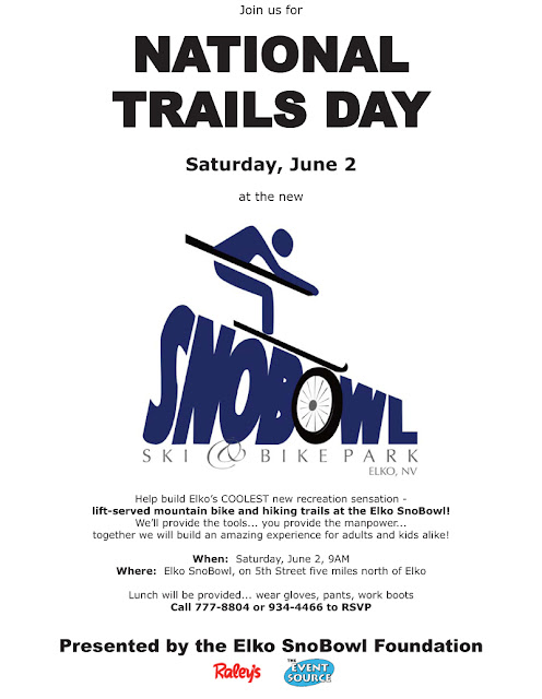
This year I'll be celebrating National Trails Day at the Elko SnoBowl Ski & Bike Park, five miles north of Elko on North 5th Street. We'll be working on two projects - one, finishing some benching work on the beginner MTB trail up there, and two (really exciting to me) beginning work on a NEW cross-country trail system. We'll be building a trail that leaves the SnoBowl parking lot and heads up to the saddle looker's right of the top of the lift. It'll be designed for two-way bike traffic and will be perfect for hikers and trail runners, too!
If you live in or near Elko, come on out and join us. We had almost 60 people out there last year... we got a lot of work done, enjoyed a great lunch, and played on the new trails in the afternoon. If you DON'T live near Elko, then find a Trails Day project near you. If you love trails, volunteer!
It's National Trails Day, June 2nd at a trail near you!
This year I'll be celebrating National Trails Day at the Elko SnoBowl Ski & Bike Park, five miles north of Elko on North 5th Street. We'll be working on two projects - one, finishing some benching work on the beginner MTB trail up there, and two (really exciting to me) beginning work on a NEW cross-country trail system. We'll be building a trail that leaves the SnoBowl parking lot and heads up to the saddle looker's right of the top of the lift. It'll be designed for two-way bike traffic and will be perfect for hikers and trail runners, too!
If you live in or near Elko, come on out and join us. We had almost 60 people out there last year... we got a lot of work done, enjoyed a great lunch, and played on the new trails in the afternoon. If you DON'T live near Elko, then find a Trails Day project near you. If you love trails, volunteer!

 |
Subscribe to:
Posts (Atom)